Geolocate

Tomado topographic map

Click on the map to display elevation.

About this map

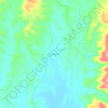
Name: Tomado topographic map, elevation, terrain.

Location: Tomado, Aleosan, North Cotabato, Soccsksargen, Philippines (7.13247 124.61303 7.17247 124.65303)

Average elevation: 66 m

Minimum elevation: 30 m

Maximum elevation: 175 m

Gear up for your next adventure:

🧥Waterproof Pants - Keep dry during rainy hiking conditions
🧊Portable Cooler - Keep food and drinks cold during outdoor adventures
🥾Trekking Boots - Durable boots for long-distance trekking
🧤Insulated Winter Gloves - Heavy-duty protection for sub-zero Canadian adventures
🧥Softshell Jacket - Windproof and breathable jacket for hiking

As an Amazon Associate, this site earns from qualifying purchases at no extra cost to you.