Geolocate

Marikit topographic map

Click on the map to display elevation.

About this map

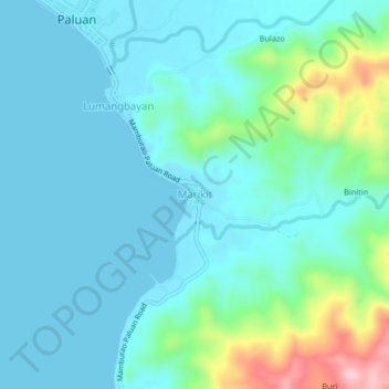
Name: Marikit topographic map, elevation, terrain.

Location: Marikit, Paluan, Occidental Mindoro, Mimaropa, Philippines (13.37783 120.45517 13.41783 120.49517)

Average elevation: 44 m

Minimum elevation: 0 m

Maximum elevation: 242 m

Gear up for your next adventure:

🥤Collapsible Travel Cup - Saves space and weight in your mess kit
🧥Fleece Jacket - Warm and lightweight jacket for layering
🧤Insulated Winter Gloves - Heavy-duty protection for sub-zero Canadian adventures
🔦LED Headtorch - Bright and durable light for night activities
🧦Crew Hiking Socks - Comfortable socks for long-distance hikes

As an Amazon Associate, this site earns from qualifying purchases at no extra cost to you.