
Esmont topographic map
Click on the map to display elevation.
About this map
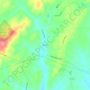
Name: Esmont topographic map, elevation, terrain.
Location: Esmont, Albemarle County, Virginia, 22937, United States (37.81125 -78.62724 37.85125 -78.58724)
Average elevation: 165 m
Minimum elevation: 124 m
Maximum elevation: 244 m
Other topographic maps
Click on a map to view its topography, its elevation and its terrain.
Beaver Creek Park
United States > Virginia > Albemarle County > Charlottesville > Wickham Pond
Average elevation: 185 m
Darden Towe Park
United States > Virginia > Albemarle County > Charlottesville > Franklin
Average elevation: 129 m