
Make a donation
Gear up for your next adventure:
As an Amazon Associate, this site earns from qualifying purchases at no extra cost to you.
Neuerode topographic map
Click on the map to display elevation.
Make a donation
Gear up for your next adventure:
As an Amazon Associate, this site earns from qualifying purchases at no extra cost to you.
About this map
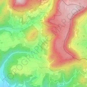
Name: Neuerode topographic map, elevation, terrain.
Location: Neuerode, Meinhard, Werra-Meißner-Kreis, Hesse, Germany (51.21368 10.02947 51.24557 10.07893)
Average elevation: 357 m
Minimum elevation: 173 m
Maximum elevation: 531 m
Make a donation
Gear up for your next adventure:
As an Amazon Associate, this site earns from qualifying purchases at no extra cost to you.
Other topographic maps
Click on a map to view its topography, its elevation and its terrain.
Make a donation
Gear up for your next adventure:
As an Amazon Associate, this site earns from qualifying purchases at no extra cost to you.
Frankershausen
Germany > Hesse > Werra-Meißner-Kreis > Berkatal > Frankershausen
Average elevation: 291 m