
Astorga topographic map
Interactive map
Click on the map to display elevation.
About this map
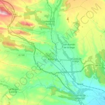
Name: Astorga topographic map, elevation, terrain.
Location: Astorga, Maragatería, León, Castilië en León, Spanje (42.43745 -6.20632 42.48958 -6.03009)
Average elevation: 899 m
Minimum elevation: 805 m
Maximum elevation: 1,098 m
Other topographic maps
Click on a map to view its topography, its elevation and its terrain.
Astorga
Spanje > Castilië en León > Astorga > Astorga
Astorga, León, Castilië en León, 24700, Spanje
Average elevation: 873 m