
Thank you for supporting this site ❤️
Make a donation
Make a donation
Gear up for your next adventure:
As an Amazon Associate, this site earns from qualifying purchases at no extra cost to you.
Gouglersville topographic map
Click on the map to display elevation.
Thank you for supporting this site ❤️
Make a donation
Make a donation
Gear up for your next adventure:
As an Amazon Associate, this site earns from qualifying purchases at no extra cost to you.
About this map
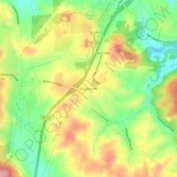
Name: Gouglersville topographic map, elevation, terrain.
Average elevation: 212 m
Minimum elevation: 146 m
Maximum elevation: 282 m
Thank you for supporting this site ❤️
Make a donation
Make a donation
Gear up for your next adventure:
As an Amazon Associate, this site earns from qualifying purchases at no extra cost to you.
Other topographic maps
Click on a map to view its topography, its elevation and its terrain.
Montrose Manor Playground
United States > Pennsylvania > Berks County > Cumru Township > Montrose
Average elevation: 130 m
Flying Hills
United States > Pennsylvania > Berks County > Cumru Township > Flying Hills Village
Average elevation: 135 m