Geolocate

Walnut Grove topographic map

Click on the map to display elevation.

About this map

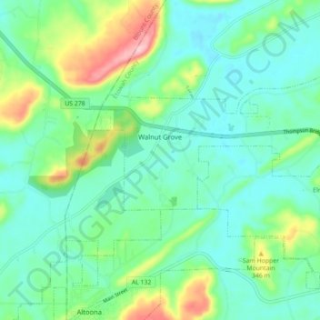
Name: Walnut Grove topographic map, elevation, terrain.

Location: Walnut Grove, Etowah County, Alabama, 35990, United States (34.03710 -86.32460 34.08336 -86.23644)

Average elevation: 284 m

Minimum elevation: 240 m

Maximum elevation: 412 m

Other topographic maps

Click on a map to view its topography, its elevation and its terrain.

Gadsden

United States > Alabama > Etowah County > Gadsden > Gadsden

Average elevation: 179 m

Pilgrims Rest

United States > Alabama > Etowah County > Southside

Average elevation: 177 m

Williams

United States > Alabama > Etowah County > Rainbow City

Average elevation: 185 m

Keeling Island

United States > Alabama > Etowah County

Average elevation: 232 m

Ballplay

United States > Alabama > Etowah County

Average elevation: 168 m

Monte Vista

United States > Alabama > Etowah County > Gadsden

Average elevation: 219 m

Shiloh

United States > Alabama > Etowah County > Shiloh

Average elevation: 195 m

Ridgeville

United States > Alabama > Etowah County

Average elevation: 209 m

Gear up for your next adventure:

🧥Softshell Hiking Jacket - The perfect balance of wind protection and breathability
🛶Waterproof Dry Bags - Keep electronics and clothes dry during river crossings
🧥Waterproof Pants - Keep dry during rainy hiking conditions
🧼Travel Hand Sanitizer - Keep hands clean when water is scarce
🧥Fleece Jacket - Warm and lightweight jacket for layering

As an Amazon Associate, this site earns from qualifying purchases at no extra cost to you.