Geolocate

Scanlon topographic map

Click on the map to display elevation.

About this map

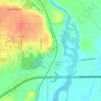
Name: Scanlon topographic map, elevation, terrain.

Location: Scanlon, Carlton County, Minnesota, United States (46.69915 -92.43880 46.71432 -92.41837)

Average elevation: 354 m

Minimum elevation: 334 m

Maximum elevation: 386 m

Other topographic maps

Click on a map to view its topography, its elevation and its terrain.

Mahtowa

United States > Minnesota > Carlton County

Average elevation: 356 m

Esko

United States > Minnesota > Carlton County

Average elevation: 360 m

Atkinson

United States > Minnesota > Carlton County

Average elevation: 353 m

Automba

United States > Minnesota > Carlton County

Average elevation: 390 m

Holyoke

United States > Minnesota > Carlton County

Average elevation: 312 m

Perch Lake

United States > Minnesota > Carlton County

Average elevation: 399 m

Thomson

United States > Minnesota > Carlton County > Carlton

Average elevation: 327 m

Corona

United States > Minnesota > Carlton County

Average elevation: 396 m

Duesler

United States > Minnesota > Carlton County

Average elevation: 311 m

Harney

United States > Minnesota > Carlton County

Average elevation: 364 m

Iverson

United States > Minnesota > Carlton County

Average elevation: 372 m

Gear up for your next adventure:

🔦LED Flashlight - Powerful and long-lasting flashlight for camping and emergencies
🪑Ultralight Camping Stool - Compact seating for rest stops during long hikes
🧣Merino Neck Gaiter - Protects against wind, sun, and cold at high altitudes
🧴Waterproofing Spray - Restore the DWR coating on jackets and tents
💧Reusable Water Bottle - Durable water bottles for hydration on trails

As an Amazon Associate, this site earns from qualifying purchases at no extra cost to you.