
Make a donation
Gear up for your next adventure:
As an Amazon Associate, this site earns from qualifying purchases at no extra cost to you.
Avalon topographic map
Click on the map to display elevation.
Make a donation
Gear up for your next adventure:
As an Amazon Associate, this site earns from qualifying purchases at no extra cost to you.
Avalon
According to the United States Census Bureau, the borough has a total area of 0.7 square miles (1.8 km2), of which 0.6 square miles (1.6 km2) is land and 0.1 square miles (0.26 km2) is water. Its average elevation is 932 feet (284 m) above sea level.
Make a donation
Gear up for your next adventure:
As an Amazon Associate, this site earns from qualifying purchases at no extra cost to you.
About this map
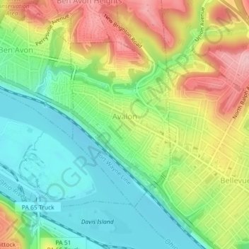
Name: Avalon topographic map, elevation, terrain.
Location: Avalon, Allegheny County, Pennsylvania, 15202, United States (40.49101 -80.07536 40.50901 -80.06091)
Average elevation: 275 m
Minimum elevation: 212 m
Maximum elevation: 365 m
Make a donation
Gear up for your next adventure:
As an Amazon Associate, this site earns from qualifying purchases at no extra cost to you.
Other topographic maps
Click on a map to view its topography, its elevation and its terrain.
Morgan
United States > Pennsylvania > Allegheny County > South Fayette Township
Average elevation: 314 m
Rural Ridge
United States > Pennsylvania > Allegheny County > Indiana Township
Average elevation: 329 m
Make a donation
Gear up for your next adventure:
As an Amazon Associate, this site earns from qualifying purchases at no extra cost to you.
Cuddy Hill
United States > Pennsylvania > Allegheny County > South Fayette Township
Average elevation: 328 m
Rennerdale
United States > Pennsylvania > Allegheny County > Collier Township
Average elevation: 321 m
Noblestown
United States > Pennsylvania > Allegheny County > North Fayette Township
Average elevation: 332 m
Make a donation
Gear up for your next adventure:
As an Amazon Associate, this site earns from qualifying purchases at no extra cost to you.
Industry
United States > Pennsylvania > Allegheny County > Elizabeth Township
Average elevation: 292 m
Greenock
United States > Pennsylvania > Allegheny County > Elizabeth Township
Average elevation: 288 m
Enlow
United States > Pennsylvania > Allegheny County > North Fayette Township
Average elevation: 329 m
Make a donation
Gear up for your next adventure:
As an Amazon Associate, this site earns from qualifying purchases at no extra cost to you.
Dorseyville
United States > Pennsylvania > Allegheny County > Indiana Township
Average elevation: 325 m
Allison Park
United States > Pennsylvania > Allegheny County > Hampton Township
Average elevation: 324 m
Bairdford
United States > Pennsylvania > Allegheny County > West Deer Township
Average elevation: 329 m
Make a donation
Gear up for your next adventure:
As an Amazon Associate, this site earns from qualifying purchases at no extra cost to you.
Buena Vista
United States > Pennsylvania > Allegheny County > Elizabeth Township
Average elevation: 291 m
Make a donation
Gear up for your next adventure:
As an Amazon Associate, this site earns from qualifying purchases at no extra cost to you.
Make a donation
Gear up for your next adventure:
As an Amazon Associate, this site earns from qualifying purchases at no extra cost to you.
Make a donation
Gear up for your next adventure:
As an Amazon Associate, this site earns from qualifying purchases at no extra cost to you.
Panther Hollow Lake
United States > Pennsylvania > Allegheny County > Pittsburgh
Average elevation: 286 m
Santiago
United States > Pennsylvania > Allegheny County > North Fayette Township
Average elevation: 354 m
Make a donation
Gear up for your next adventure:
As an Amazon Associate, this site earns from qualifying purchases at no extra cost to you.
Lovedale
United States > Pennsylvania > Allegheny County > Elizabeth Township
Average elevation: 298 m
Mount Vernon
United States > Pennsylvania > Allegheny County > Elizabeth Township
Average elevation: 299 m
Make a donation
Gear up for your next adventure:
As an Amazon Associate, this site earns from qualifying purchases at no extra cost to you.
Talley Cavey
United States > Pennsylvania > Allegheny County > Hampton Township
Average elevation: 341 m
Piney Fork
United States > Pennsylvania > Allegheny County > South Park Township
Average elevation: 325 m
Make a donation
Gear up for your next adventure:
As an Amazon Associate, this site earns from qualifying purchases at no extra cost to you.
Fox Ridge
United States > Pennsylvania > Allegheny County > McCandless > Fox Ridge
Average elevation: 349 m
Black mulberry (Morus nigra)
United States > Pennsylvania > Allegheny County > Pittsburgh
Average elevation: 296 m
Make a donation
Gear up for your next adventure:
As an Amazon Associate, this site earns from qualifying purchases at no extra cost to you.