
Thank you for supporting this site ❤️
Make a donation
Make a donation
Gear up for your next adventure:
As an Amazon Associate, this site earns from qualifying purchases at no extra cost to you.
Lechfeld topographic map
Click on the map to display elevation.
Thank you for supporting this site ❤️
Make a donation
Make a donation
Gear up for your next adventure:
As an Amazon Associate, this site earns from qualifying purchases at no extra cost to you.
About this map
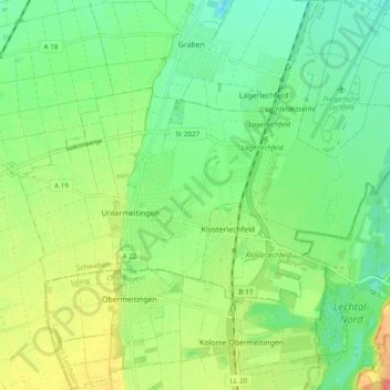
Name: Lechfeld topographic map, elevation, terrain.
Location: Lechfeld, Landkreis Augsburg, Bayern, 86836, Deutschland (48.14670 10.77966 48.18195 10.87542)
Average elevation: 561 m
Minimum elevation: 538 m
Maximum elevation: 600 m
Thank you for supporting this site ❤️
Make a donation
Make a donation
Gear up for your next adventure:
As an Amazon Associate, this site earns from qualifying purchases at no extra cost to you.