
Thank you for supporting this site ❤️
Make a donation
Make a donation
Gear up for your next adventure:
As an Amazon Associate, this site earns from qualifying purchases at no extra cost to you.
Planay topographic map
Click on the map to display elevation.
Thank you for supporting this site ❤️
Make a donation
Make a donation
Gear up for your next adventure:
As an Amazon Associate, this site earns from qualifying purchases at no extra cost to you.
About this map
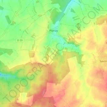
Name: Planay topographic map, elevation, terrain.
Average elevation: 306 m
Minimum elevation: 268 m
Maximum elevation: 340 m
Thank you for supporting this site ❤️
Make a donation
Make a donation
Gear up for your next adventure:
As an Amazon Associate, this site earns from qualifying purchases at no extra cost to you.
Other topographic maps
Click on a map to view its topography, its elevation and its terrain.
Les Corcelles
Frankrijk > Bourgondië-Franche-Comté > Côte-d'Or > Villiers-en-Morvan
Average elevation: 467 m
Le Petit Cirey
Frankrijk > Bourgondië-Franche-Comté > Côte-d'Or > Cirey-lès-Nolay
Average elevation: 416 m