
General Sánchez Cerro topographic map
Interactive map
Click on the map to display elevation.
About this map
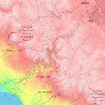
Name: General Sánchez Cerro topographic map, elevation, terrain.
Average elevation: 3,660 m
Minimum elevation: 2,598 m
Maximum elevation: 4,714 m
Other topographic maps
Click on a map to view its topography, its elevation and its terrain.
Volcán Huaynaputina (Ver Nevado Huaynaputina)
Volcán Huaynaputina (Ver Nevado Huaynaputina), Matalaque, General Sánchez Cerro, Moquegua, Peru
Average elevation: 4,379 m