
Make a donation
Gear up for your next adventure:
As an Amazon Associate, this site earns from qualifying purchases at no extra cost to you.
San Roque topographic map
Click on the map to display elevation.
Make a donation
Gear up for your next adventure:
As an Amazon Associate, this site earns from qualifying purchases at no extra cost to you.
About this map
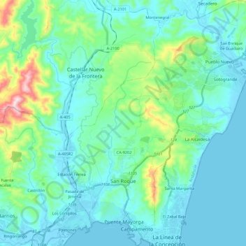
Name: San Roque topographic map, elevation, terrain.
Location: San Roque, Campo de Gibraltar, Cádiz, Andalusia, Spain (36.16380 -5.43934 36.33793 -5.25237)
Average elevation: 73 m
Minimum elevation: -6 m
Maximum elevation: 438 m
Make a donation
Gear up for your next adventure:
As an Amazon Associate, this site earns from qualifying purchases at no extra cost to you.
Other topographic maps
Click on a map to view its topography, its elevation and its terrain.
Castillo de Castellar
Spain > Andalusia > Campo de Gibraltar > Castellar de la Frontera > Castellar Viejo de la Frontera
Average elevation: 102 m
Make a donation
Gear up for your next adventure:
As an Amazon Associate, this site earns from qualifying purchases at no extra cost to you.