Geolocate

Leslie topographic map

Click on the map to display elevation.

About this map

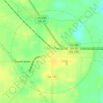
Name: Leslie topographic map, elevation, terrain.

Location: Leslie, Sumter County, Georgia, United States (31.94349 -84.09909 31.96529 -84.07358)

Average elevation: 102 m

Minimum elevation: 88 m

Maximum elevation: 112 m

Other topographic maps

Click on a map to view its topography, its elevation and its terrain.

De Soto

United States > Georgia > Sumter County

Average elevation: 94 m

Concord

United States > Georgia > Sumter County

Average elevation: 151 m

Gear up for your next adventure:

🧥Waterproof Jacket - Lightweight rain jackets for hiking and outdoor activities
🧥Ultralight Puffy Jacket - Maximum warmth that packs down to the size of an orange
🦯Trekking Poles - Reduced impact on joints for steep topographic climbs
🧥Packable Rain Jacket - Breathable waterproof layer for unpredictable weather
🎒Hiking Daypack - Lightweight and durable backpacks for day trips and excursions

As an Amazon Associate, this site earns from qualifying purchases at no extra cost to you.