Geolocate

Nanggung topographic map

Click on the map to display elevation.

About this map

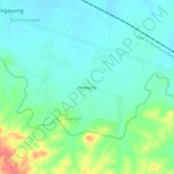
Name: Nanggung topographic map, elevation, terrain.

Location: Nanggung, Mangin, Grobogan, Central Java, Java, Indonesia (-7.15161 110.78049 -7.11161 110.82049)

Average elevation: 45 m

Minimum elevation: 25 m

Maximum elevation: 101 m

Gear up for your next adventure:

🧭GPS Tracker - Track your location in remote areas safely
🔋Emergency Crank Radio - Weather alerts and power without needing batteries
🧼Biodegradable Camp Soap - Environmentally friendly cleaning for gear and body
🔦LED Headtorch - Bright and durable light for night activities
🧼Travel Hand Sanitizer - Keep hands clean when water is scarce

As an Amazon Associate, this site earns from qualifying purchases at no extra cost to you.