
Mount Morgan topographic map
Interactive map
Click on the map to display elevation.
About this map
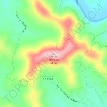
Name: Mount Morgan topographic map, elevation, terrain.
Location: Mount Morgan, Whitley County, Kentucky, 40769, USA (36.74392 -84.19471 36.74402 -84.19461)
Average elevation: 374 m
Minimum elevation: 274 m
Maximum elevation: 530 m
Other topographic maps
Click on a map to view its topography, its elevation and its terrain.
Brandenburg
USA > Kentucky > Brandenburg
Brandenburg, Meade County, Kentucky, USA
Average elevation: 168 m
Mount Washington
USA > Kentucky > Mount Washington
Mount Washington, Bullitt County, Kentucky, 40047, USA
Average elevation: 184 m
Sugar Loaf Mountain
Sugar Loaf Mountain, Fleming County, Kentucky, USA
Average elevation: 259 m
Spring Hill
USA > Kentucky > Spring Hill
Spring Hill, Hickman County, Kentucky, USA
Average elevation: 121 m
Gardenside
USA > Kentucky > Gardenside
Gardenside, Fayette County, Kentucky, 40504, USA
Average elevation: 293 m
Little Georgetown
USA > Kentucky > Little Georgetown
Little Georgetown, Fayette County, Kentucky, 40513, USA
Average elevation: 285 m
The Meadow
USA > Kentucky > The Meadow
The Meadow, Jefferson County, Kentucky, 40242, USA
Average elevation: 200 m