
Make a donation
Gear up for your next adventure:
As an Amazon Associate, this site earns from qualifying purchases at no extra cost to you.
Cima de' Piazzi topographic map
Click on the map to display elevation.
Make a donation
Gear up for your next adventure:
As an Amazon Associate, this site earns from qualifying purchases at no extra cost to you.
Cima de' Piazzi
Der Berg liegt zwischen dem Valle Grosina, dem Valdisotto und dem Valdidentro. Sie besteht aus drei Bergkämmen, wobei der westnordwestliche und der nordöstliche am Gipfel zusammenlaufen. Die beiden Kämme umschließen die vergletscherte Nordseite des Berges. Der Südkamm zweigt etwas östlich des Gipfels ab und verläuft bald an Höhe verlierend in südwestlicher Richtung bis zum Colle di Piazzi (3022 m) weiter. Der Nordostkamm führt nur leicht an Höhe verlierend bis zum Colle Rinalpi (2995 m), während der zerklüftete westliche Kamm sich in nordwestlicher Richtung bis zum Corno Sinigaglia (2437 m), Corni di Verva (3315 m) und zum Colle delle Pecore (2437 m) entlangzieht.
Make a donation
Gear up for your next adventure:
As an Amazon Associate, this site earns from qualifying purchases at no extra cost to you.
About this map
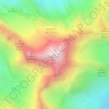
Name: Cima de' Piazzi topographic map, elevation, terrain.
Average elevation: 2,802 m
Minimum elevation: 2,301 m
Maximum elevation: 3,402 m
Make a donation
Gear up for your next adventure:
As an Amazon Associate, this site earns from qualifying purchases at no extra cost to you.