Geolocate

Mount Marami topographic map

Click on the map to display elevation.

Mount Marami

Mount Marami, or Mataas na Gulod Boulders, is a cliff at the southern portion of Mount Mataas na Gulod in Cavite province on the island of Luzon, Philippines. The mountain rises to an elevation of 633 m (2,077 ft) above mean sea level and is one of the ancient volcanic features of Bataan Arc.

Wikipedia (CC-BY-SA 3.0)

About this map

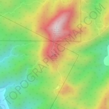
Name: Mount Marami topographic map, elevation, terrain.

Location: Mount Marami, Nasugbu, Batangas, Calabarzon, 4231, Philippines (14.19855 120.68602 14.19865 120.68612)

Average elevation: 329 m

Minimum elevation: 57 m

Maximum elevation: 623 m

Other topographic maps

Click on a map to view its topography, its elevation and its terrain.

Talamitam

Philippines > Batangas > Nasugbu > Kayrilaw

Average elevation: 328 m

Gear up for your next adventure:

🧥Waterproof Jacket - Lightweight rain jackets for hiking and outdoor activities
🧣Merino Neck Gaiter - Protects against wind, sun, and cold at high altitudes
🧢Outdoor Cap - Protective cap for sun and rain during hikes
💧Collapsible Water Bottle - Space-saving water bottle for outdoor activities
🔭Compact Monocular - One-handed bird watching and trail spotting

As an Amazon Associate, this site earns from qualifying purchases at no extra cost to you.