
Make a donation
Gear up for your next adventure:
As an Amazon Associate, this site earns from qualifying purchases at no extra cost to you.
Wingene topographic map
Click on the map to display elevation.
Make a donation
Gear up for your next adventure:
As an Amazon Associate, this site earns from qualifying purchases at no extra cost to you.
Wingene
Wingene ligt in het overgangsgebied van Zandig Vlaanderen in het boorden en Zandlemig Vlaanderen (Plateau van Tielt) in het zuiden. De hoogte bedraagt 15-39 meter. De belangrijkste waterloop is de Ringbeek die oostelijk van de dorpskom in noordelijke richting stroomt. Het landschap is licht heuvelachtig. Natuurgebieden zijn: Munkebossen, De Gulke Putten, Bulskampveld, Blauwhuisbossen en Vagevuurbossen.
Make a donation
Gear up for your next adventure:
As an Amazon Associate, this site earns from qualifying purchases at no extra cost to you.
About this map
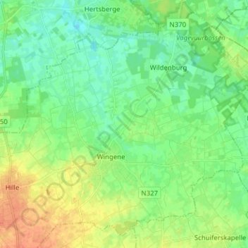
Name: Wingene topographic map, elevation, terrain.
Location: Wingene, Tielt, West-Vlaanderen, Vlaanderen, België (51.03279 3.22348 51.10427 3.34956)
Average elevation: 21 m
Minimum elevation: 8 m
Maximum elevation: 43 m
Make a donation
Gear up for your next adventure:
As an Amazon Associate, this site earns from qualifying purchases at no extra cost to you.
Other topographic maps
Click on a map to view its topography, its elevation and its terrain.
Make a donation
Gear up for your next adventure:
As an Amazon Associate, this site earns from qualifying purchases at no extra cost to you.