Geolocate

Orillia topographic map

Click on the map to display elevation.

About this map

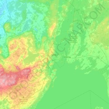
Name: Orillia topographic map, elevation, terrain.

Location: Orillia, Central Ontario, Ontario, L3V 5A9, Canada (44.44921 -79.57756 44.76921 -79.25756)

Average elevation: 236 m

Minimum elevation: 176 m

Maximum elevation: 392 m

Orillia trails, hiking, mountain biking, running and outdoor activities

Gear up for your next adventure:

🧥Waterproof Pants - Keep dry during rainy hiking conditions
🥾Hiking Gaiters - Protect legs and shoes from mud, snow, and debris
👟Sport Hiking Sandals - Breathable footwear for water crossings and camp rest
🧥Softshell Jacket - Windproof and breathable jacket for hiking
🧢Outdoor Cap - Protective cap for sun and rain during hikes

As an Amazon Associate, this site earns from qualifying purchases at no extra cost to you.