
Thank you for supporting this site ❤️
Make a donation
Make a donation
Gear up for your next adventure:
As an Amazon Associate, this site earns from qualifying purchases at no extra cost to you.
Jyura topographic map
Click on the map to display elevation.
Thank you for supporting this site ❤️
Make a donation
Make a donation
Gear up for your next adventure:
As an Amazon Associate, this site earns from qualifying purchases at no extra cost to you.
About this map
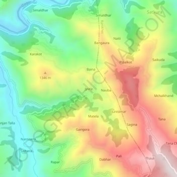
Name: Jyura topographic map, elevation, terrain.
Location: Jyura, Bhikiasain, Almora, Uttarakhand, 263680, Inde (29.65871 79.27397 29.69871 79.31397)
Average elevation: 1,152 m
Minimum elevation: 777 m
Maximum elevation: 1,644 m
Thank you for supporting this site ❤️
Make a donation
Make a donation
Gear up for your next adventure:
As an Amazon Associate, this site earns from qualifying purchases at no extra cost to you.