
Thank you for supporting this site ❤️
Make a donation
Make a donation
Gear up for your next adventure:
As an Amazon Associate, this site earns from qualifying purchases at no extra cost to you.
Huatasjapo topographic map
Click on the map to display elevation.
Thank you for supporting this site ❤️
Make a donation
Make a donation
Gear up for your next adventure:
As an Amazon Associate, this site earns from qualifying purchases at no extra cost to you.
About this map
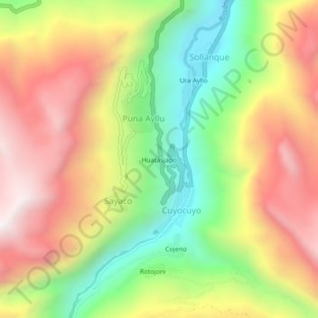
Name: Huatasjapo topographic map, elevation, terrain.
Location: Huatasjapo, Puna Ayllu, Cuyocuyo, Sandia, Puno, Perú (-14.48361 -69.55983 -14.44361 -69.51983)
Average elevation: 3,912 m
Minimum elevation: 3,356 m
Maximum elevation: 4,470 m
Thank you for supporting this site ❤️
Make a donation
Make a donation
Gear up for your next adventure:
As an Amazon Associate, this site earns from qualifying purchases at no extra cost to you.