Geolocate

Leitza topographic map

Click on the map to display elevation.

About this map

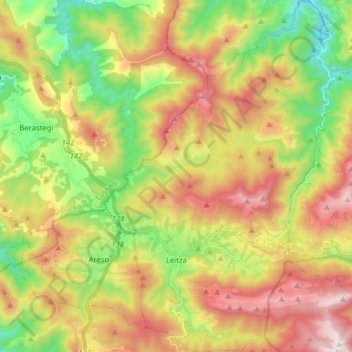
Name: Leitza topographic map, elevation, terrain.

Location: Leitza, Larraun-Leitzaldea, Navarre, 31880, Spain (43.05080 -1.94890 43.16587 -1.84436)

Average elevation: 642 m

Minimum elevation: 182 m

Maximum elevation: 1,192 m

Other topographic maps

Click on a map to view its topography, its elevation and its terrain.

Ear

Spain > Navarre > Larraun-Leitzaldea > Larraun

Average elevation: 824 m

Gear up for your next adventure:

🚲Bike Repair Kit - Essential tools for on-trail mechanical issues
📷Outdoor Action Camera - Capture high-elevation views and rugged adventures
🧤Rechargeable Heated Gloves - Extreme warmth for Canadian winter expeditions
🧥Softshell Jacket - Windproof and breathable jacket for hiking
🛏️Sleeping Bag - Warm and compact sleeping bags for outdoor camping

As an Amazon Associate, this site earns from qualifying purchases at no extra cost to you.