Geolocate

Moana topographic map

Click on the map to display elevation.

About this map

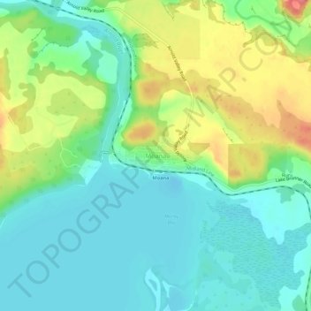
Name: Moana topographic map, elevation, terrain.

Location: Moana, Grey District, West Coast, 7845, New Zealand (-42.59495 171.45768 -42.55495 171.49768)

Average elevation: 110 m

Minimum elevation: 84 m

Maximum elevation: 163 m

Other topographic maps

Click on a map to view its topography, its elevation and its terrain.

Arnold River

New Zealand > West Coast > Grey District > Moana

Average elevation: 153 m

Lake Haupiri

New Zealand > West Coast > Grey District

Average elevation: 223 m

Lake Avernus

New Zealand > West Coast > Grey District

Average elevation: 1,335 m

Gear up for your next adventure:

🥾Mountain Trail Shoes - High-traction shoes for mountain trails
📷Outdoor Action Camera - Capture high-elevation views and rugged adventures
🌬️Windproof Camp Stove - Efficient cooking even on exposed mountain peaks
🥽Outdoor Goggles - Protective eyewear for outdoor activities
🦟Insect Repellent - Keep mosquitoes and black flies away in wooded areas

As an Amazon Associate, this site earns from qualifying purchases at no extra cost to you.