Geolocate

Fort Mountain topographic map

Click on the map to display elevation.

About this map

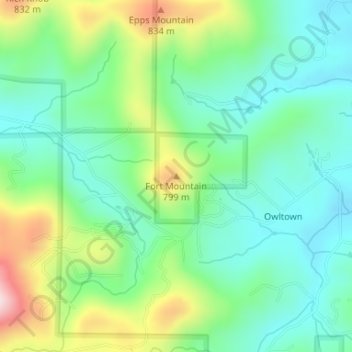
Name: Fort Mountain topographic map, elevation, terrain.

Location: Fort Mountain, Union County, Georgia, United States (34.81615 -83.94996 34.81625 -83.94986)

Average elevation: 679 m

Minimum elevation: 579 m

Maximum elevation: 902 m

Other topographic maps

Click on a map to view its topography, its elevation and its terrain.

Meeks Park

United States > Georgia > Union County

Average elevation: 563 m

Gear up for your next adventure:

🧦Hiking Liner Socks - Thin base layer to prevent friction and blisters
🧴Insect Repellent - Protect yourself from bugs during outdoor adventures
🧦Crew Hiking Socks - Comfortable socks for long-distance hikes
🧦Thermal Socks - Warm socks for winter hiking or camping
🥾Approach Shoes - Shoes designed for climbing approaches and rugged trails

As an Amazon Associate, this site earns from qualifying purchases at no extra cost to you.