
Jaun topographic map
Interactive map
Click on the map to display elevation.
About this map
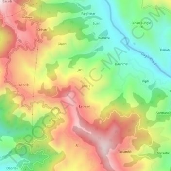
Name: Jaun topographic map, elevation, terrain.
Location: Jaun, Jogindarnagar, Mandi, Himachal Pradesh, 175014, Inde (31.84360 76.78038 31.88360 76.82038)
Average elevation: 1,120 m
Minimum elevation: 734 m
Maximum elevation: 1,556 m
Other topographic maps
Click on a map to view its topography, its elevation and its terrain.
Pabo
Inde > Himachal Pradesh > Jogindarnagar
Pabo, Jogindarnagar, Mandi District, Himachal Pradesh, 175040, Inde
Average elevation: 1,038 m