
Make a donation
Gear up for your next adventure:
As an Amazon Associate, this site earns from qualifying purchases at no extra cost to you.
Arfurt topographic map
Click on the map to display elevation.
Make a donation
Gear up for your next adventure:
As an Amazon Associate, this site earns from qualifying purchases at no extra cost to you.
Arfurt
Der Ort selbst liegt auf rund 160 Metern Höhe. Unmittelbar an seinem Südostrand fällt das Gelände bis zur Lahn rund 50 Meter steil ab. Im Westen des Orts gestaltet sich dieser Übergang wesentlich sanfter, so dass auch der Hang bis zum Lahnufer hinab bebaut ist.
Make a donation
Gear up for your next adventure:
As an Amazon Associate, this site earns from qualifying purchases at no extra cost to you.
About this map
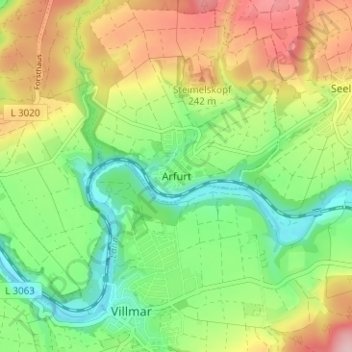
Name: Arfurt topographic map, elevation, terrain.
Average elevation: 188 m
Minimum elevation: 114 m
Maximum elevation: 291 m
Make a donation
Gear up for your next adventure:
As an Amazon Associate, this site earns from qualifying purchases at no extra cost to you.