Geolocate

Taugtog topographic map

Click on the map to display elevation.

About this map

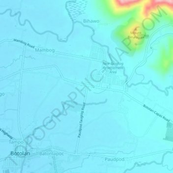
Name: Taugtog topographic map, elevation, terrain.

Location: Taugtog, Zambales, Central Luzon, 2202, Philippines (15.28449 120.02064 15.32449 120.06064)

Average elevation: 24 m

Minimum elevation: 9 m

Maximum elevation: 186 m

Gear up for your next adventure:

🥾Waterproof Hiking Boots - Essential footwear for rugged terrain and wet Canadian trails
💡LED Headlamp - Hands-free illumination for night hiking and camping
🥾Mountain Hiking Boots - High-traction boots for rocky terrain
🧣Merino Neck Gaiter - Protects against wind, sun, and cold at high altitudes
🪑Ultralight Camping Stool - Compact seating for rest stops during long hikes

As an Amazon Associate, this site earns from qualifying purchases at no extra cost to you.