Geolocate

Arnold topographic map

Click on the map to display elevation.

About this map

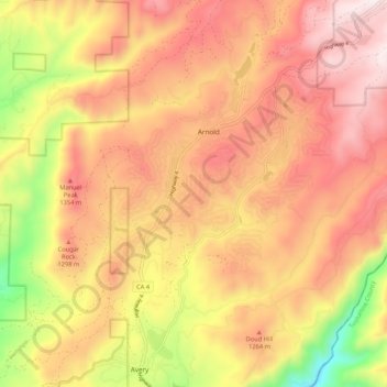
Name: Arnold topographic map, elevation, terrain.

Location: Arnold, Calaveras County, California, United States (38.20457 -120.41123 38.27966 -120.30548)

Average elevation: 1,171 m

Minimum elevation: 651 m

Maximum elevation: 1,525 m

Other topographic maps

Click on a map to view its topography, its elevation and its terrain.

Manuel Mill

United States > California > Calaveras County > Arnold

Average elevation: 1,229 m

Manuel Mill

United States > California > Calaveras County > Arnold

Average elevation: 1,229 m

Gear up for your next adventure:

🌬️Windproof Camp Stove - Efficient cooking even on exposed mountain peaks
🥾Hiking Boots - Sturdy boots providing ankle support and traction on rugged trails
🦯Trekking Poles - Reduced impact on joints for steep topographic climbs
💡Compact LED Flashlight - Powerful and portable flashlight for outdoor use
🥾Approach Shoes - Shoes designed for climbing approaches and rugged trails

As an Amazon Associate, this site earns from qualifying purchases at no extra cost to you.