
Thank you for supporting this site ❤️
Make a donation
Make a donation
Gear up for your next adventure:
As an Amazon Associate, this site earns from qualifying purchases at no extra cost to you.
Tyrone topographic map
Click on the map to display elevation.
Thank you for supporting this site ❤️
Make a donation
Make a donation
Gear up for your next adventure:
As an Amazon Associate, this site earns from qualifying purchases at no extra cost to you.
About this map
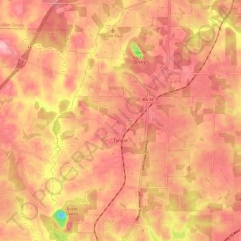
Name: Tyrone topographic map, elevation, terrain.
Location: Tyrone, Fayette County, Georgia, 30290, United States (33.43524 -84.62722 33.52146 -84.55423)
Average elevation: 283 m
Minimum elevation: 180 m
Maximum elevation: 323 m
Thank you for supporting this site ❤️
Make a donation
Make a donation
Gear up for your next adventure:
As an Amazon Associate, this site earns from qualifying purchases at no extra cost to you.
Other topographic maps
Click on a map to view its topography, its elevation and its terrain.
Tamerlane
United States > Georgia > Fayette County > Peachtree City > Tamerlane
Average elevation: 247 m