Geolocate

Charilla topographic map

Click on the map to display elevation.

About this map

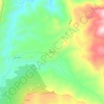
Name: Charilla topographic map, elevation, terrain.

Location: Charilla, Alcalá la Real, Jaén, Andalucía, 23692, España (37.47580 -3.92870 37.51580 -3.88870)

Average elevation: 921 m

Minimum elevation: 739 m

Maximum elevation: 1,199 m

Gear up for your next adventure:

🥾Mountain Hiking Shoes - Shoes with superior grip for mountainous terrain
🧭GPS Tracker - Track your location in remote areas safely
🥾Mountain Trail Shoes - High-traction shoes for mountain trails
🧰Multitool Knife - Compact and versatile tool for outdoor use
🎒Fully Waterproof Backpack - Total protection for photography gear and electronics

As an Amazon Associate, this site earns from qualifying purchases at no extra cost to you.