Make a donation
Gear up for your next adventure:
As an Amazon Associate, this site earns from qualifying purchases at no extra cost to you.
Ashburnham topographic map
Click on the map to display elevation.
Make a donation
Gear up for your next adventure:
As an Amazon Associate, this site earns from qualifying purchases at no extra cost to you.
Ashburnham
According to the United States Census Bureau, the town has a total area of 41.0 square miles (106 km2), of which 38.7 square miles (100 km2) is land and 2.3 square miles (6.0 km2) (5.68%) is water. Ashburnham has two distinct topographical areas, hilly to the east and relatively flat high ground to the west. To the east, Mount Watatic and Little Watatic Mountain rise in the northeastern part of town, with Jewell Hill to the southeast and Blood Hill rising just over the town line. In the western part of town are several lakes, including Lake Wampanoag, Sunset Lake, Lake Watatic, Wallace Pond, and the Upper & Lower Naukeag Lakes, all of which (except Lake Wampanoag) feed into the headwaters of the Millers River, which flows westward towards the Connecticut River. Several brooks also feed into these lakes and ponds, along with several others between the hills in the eastern part of town. Several areas scattered around the town are protected as part of Ashburnham State Forest, as well as two smaller areas which are parts of Mount Watatic State Wildlife Management Area and a small portion of the High Ridge Wildlife Management Area to the south.
Make a donation
Gear up for your next adventure:
As an Amazon Associate, this site earns from qualifying purchases at no extra cost to you.
About this map
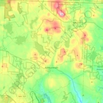
Name: Ashburnham topographic map, elevation, terrain.
Average elevation: 342 m
Minimum elevation: 216 m
Maximum elevation: 544 m
Make a donation
Gear up for your next adventure:
As an Amazon Associate, this site earns from qualifying purchases at no extra cost to you.
Other topographic maps
Click on a map to view its topography, its elevation and its terrain.
Crow Hill Ledges
United States > Massachusetts > Worcester County > Westminster
Average elevation: 293 m
Make a donation
Gear up for your next adventure:
As an Amazon Associate, this site earns from qualifying purchases at no extra cost to you.
Central (Stanley) Woolen Mill District Park
United States > Massachusetts > Worcester County > Uxbridge
Average elevation: 80 m
Make a donation
Gear up for your next adventure:
As an Amazon Associate, this site earns from qualifying purchases at no extra cost to you.
Hadwen Park
United States > Massachusetts > Worcester County > Worcester > Heard Street
Average elevation: 166 m
Make a donation
Gear up for your next adventure:
As an Amazon Associate, this site earns from qualifying purchases at no extra cost to you.
Northbridge Center
United States > Massachusetts > Worcester County > Northbridge
Average elevation: 124 m
Make a donation
Gear up for your next adventure:
As an Amazon Associate, this site earns from qualifying purchases at no extra cost to you.
Wachusett Station
United States > Massachusetts > Worcester County > Fitchburg
Average elevation: 229 m
Tatnuck
United States > Massachusetts > Worcester County > Worcester > Tatnuck Square
Average elevation: 221 m
Make a donation
Gear up for your next adventure:
As an Amazon Associate, this site earns from qualifying purchases at no extra cost to you.
Blackburn Village
United States > Massachusetts > Worcester County > Ashburnham
Average elevation: 326 m
Phillipston Four Corners
United States > Massachusetts > Worcester County > Phillipston
Average elevation: 335 m
Make a donation
Gear up for your next adventure:
As an Amazon Associate, this site earns from qualifying purchases at no extra cost to you.
Make a donation
Gear up for your next adventure:
As an Amazon Associate, this site earns from qualifying purchases at no extra cost to you.
Make a donation
Gear up for your next adventure:
As an Amazon Associate, this site earns from qualifying purchases at no extra cost to you.
Institute Park
United States > Massachusetts > Worcester County > Worcester > Belmont Hill
Average elevation: 170 m
Make a donation
Gear up for your next adventure:
As an Amazon Associate, this site earns from qualifying purchases at no extra cost to you.
Thompsons Pond Dam
United States > Massachusetts > Worcester County > Spencer
Average elevation: 278 m
Make a donation
Gear up for your next adventure:
As an Amazon Associate, this site earns from qualifying purchases at no extra cost to you.
Make a donation
Gear up for your next adventure:
As an Amazon Associate, this site earns from qualifying purchases at no extra cost to you.
Make a donation
Gear up for your next adventure:
As an Amazon Associate, this site earns from qualifying purchases at no extra cost to you.
Make a donation
Gear up for your next adventure:
As an Amazon Associate, this site earns from qualifying purchases at no extra cost to you.
Make a donation
Gear up for your next adventure:
As an Amazon Associate, this site earns from qualifying purchases at no extra cost to you.
Jefferson
United States > Massachusetts > Worcester County > Holden > Jefferson
Average elevation: 248 m
Make a donation
Gear up for your next adventure:
As an Amazon Associate, this site earns from qualifying purchases at no extra cost to you.
West Upton
United States > Massachusetts > Worcester County > Upton > West Upton
Average elevation: 111 m
Hadwen Arboretum
United States > Massachusetts > Worcester County > Worcester > Main South
Average elevation: 165 m
South Charlton Reservoir
United States > Massachusetts > Worcester County > Charlton > South Charlton
Average elevation: 203 m
Make a donation
Gear up for your next adventure:
As an Amazon Associate, this site earns from qualifying purchases at no extra cost to you.
Martha Templeton Rock
United States > Massachusetts > Worcester County > Southborough
Average elevation: 95 m
Make a donation
Gear up for your next adventure:
As an Amazon Associate, this site earns from qualifying purchases at no extra cost to you.
Turkey Hill Shores
United States > Massachusetts > Worcester County > Rutland
Average elevation: 312 m
Make a donation
Gear up for your next adventure:
As an Amazon Associate, this site earns from qualifying purchases at no extra cost to you.
