Geolocate

Talavera topographic map

Click on the map to display elevation.

About this map

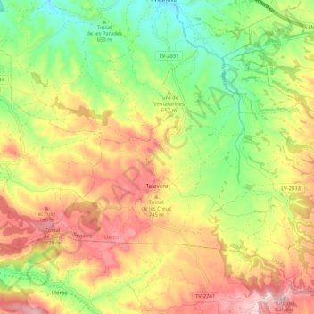
Name: Talavera topographic map, elevation, terrain.

Location: Talavera, Segarra, Lleida, Catalonia, Spain (41.55628 1.30413 41.62230 1.40704)

Average elevation: 694 m

Minimum elevation: 545 m

Maximum elevation: 855 m

Gear up for your next adventure:

🪑Insulated Seat Pad - Protect your seat from cold rocks and wet logs
🧢Outdoor Visor - Breathable visor for sunny hikes
🥾Lightweight Hiking Shoes - Comfortable shoes for day hikes
🧥Fleece Jacket - Warm and lightweight jacket for layering
🧣Merino Neck Gaiter - Protects against wind, sun, and cold at high altitudes

As an Amazon Associate, this site earns from qualifying purchases at no extra cost to you.