
Make a donation
Gear up for your next adventure:
As an Amazon Associate, this site earns from qualifying purchases at no extra cost to you.
Villethierry topographic map
Click on the map to display elevation.
Make a donation
Gear up for your next adventure:
As an Amazon Associate, this site earns from qualifying purchases at no extra cost to you.
About this map
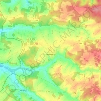
Name: Villethierry topographic map, elevation, terrain.
Average elevation: 149 m
Minimum elevation: 105 m
Maximum elevation: 196 m
Make a donation
Gear up for your next adventure:
As an Amazon Associate, this site earns from qualifying purchases at no extra cost to you.
Other topographic maps
Click on a map to view its topography, its elevation and its terrain.
Make a donation
Gear up for your next adventure:
As an Amazon Associate, this site earns from qualifying purchases at no extra cost to you.
Les miniers
France > Bourgogne-Franche-Comté > Yonne > Charny Orée de Puisaye
Average elevation: 180 m
La Levée
France > Bourgogne-Franche-Comté > Yonne > Saint-Maurice-Thizouaille
Average elevation: 151 m
Make a donation
Gear up for your next adventure:
As an Amazon Associate, this site earns from qualifying purchases at no extra cost to you.