
La Montagne topographic map
Interactive map
Click on the map to display elevation.
About this map
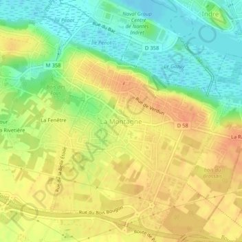
Name: La Montagne topographic map, elevation, terrain.
Average elevation: 23 m
Minimum elevation: -1 m
Maximum elevation: 41 m
Other topographic maps
Click on a map to view its topography, its elevation and its terrain.
La Brutz
France > Pays de la Loire > Loire-Atlantique > Rougé > La Grée Pothin
Average elevation: 65 m
Tharon Plage
France > Pays de la Loire > Loire-Atlantique > Saint-Michel-Chef-Chef > Tharon Plage
Average elevation: 11 m
Le Baudrier
France > Pays de la Loire > Loire-Atlantique > Chaumes-en-Retz > Arthon-en-Retz > Le Baudrier
Average elevation: 36 m