Geolocate

Anshun topographic map

Click on the map to display elevation.

About this map

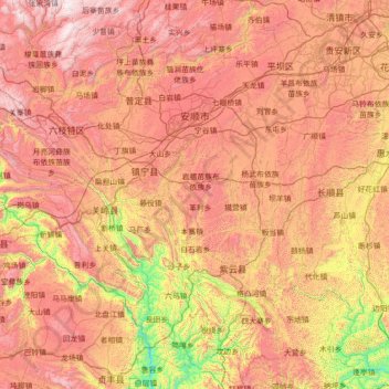
Name: Anshun topographic map, elevation, terrain.

Location: Anshun, Guizhou, 561000, China (25.35700 105.24768 26.62836 106.56469)

Average elevation: 1,227 m

Minimum elevation: 363 m

Maximum elevation: 2,139 m

Other topographic maps

Click on a map to view its topography, its elevation and its terrain.

Keji

China > Guizhou > Anlong > Sayu

Average elevation: 1,437 m

Napan

China > Guizhou > Wangmo

Average elevation: 1,078 m

Gear up for your next adventure:

🧥Insulated Jacket - Keep warm in cold outdoor conditions
🔥Camping Stove - Portable stoves to cook outdoors with ease
🧴Outdoor Sunscreen - High SPF protection for high-altitude UV exposure
🥾Waterproof Trail Shoes - Shoes designed to handle wet terrain
🧢Outdoor Visor - Breathable visor for sunny hikes

As an Amazon Associate, this site earns from qualifying purchases at no extra cost to you.