
Thank you for supporting this site ❤️
Make a donation
Make a donation
Gear up for your next adventure:
As an Amazon Associate, this site earns from qualifying purchases at no extra cost to you.
Hamla topographic map
Click on the map to display elevation.
Thank you for supporting this site ❤️
Make a donation
Make a donation
Gear up for your next adventure:
As an Amazon Associate, this site earns from qualifying purchases at no extra cost to you.
About this map
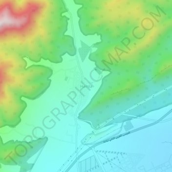
Name: Hamla topographic map, elevation, terrain.
Location: Hamla, Oued Chaaba, Daïra Batna, Batna, Algérie (35.53699 6.06444 35.57699 6.10444)
Average elevation: 1,250 m
Minimum elevation: 1,082 m
Maximum elevation: 1,708 m
Thank you for supporting this site ❤️
Make a donation
Make a donation
Gear up for your next adventure:
As an Amazon Associate, this site earns from qualifying purchases at no extra cost to you.