
Make a donation
Gear up for your next adventure:
As an Amazon Associate, this site earns from qualifying purchases at no extra cost to you.
Fitoiro topographic map
Click on the map to display elevation.
Make a donation
Gear up for your next adventure:
As an Amazon Associate, this site earns from qualifying purchases at no extra cost to you.
About this map
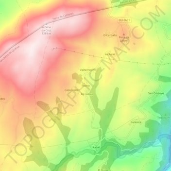
Name: Fitoiro topographic map, elevation, terrain.
Average elevation: 1,057 m
Minimum elevation: 755 m
Maximum elevation: 1,285 m
Make a donation
Gear up for your next adventure:
As an Amazon Associate, this site earns from qualifying purchases at no extra cost to you.
Other topographic maps
Click on a map to view its topography, its elevation and its terrain.
A Pobra de Trives
España > Galicia > Terra de Trives
El Bibey es el afluente más importante del río Sil. Nace en la sierra Segundera, en el municipio zamorano de Porto de Sanabria a 1840 m de altitud y constituye casi todo el límite norte del ayuntamiento. Desde su margen izquierda desembocan en él el río Navea y el San Lázaro, el Cabalar y el Fiscaíño,…
Average elevation: 838 m