
Make a donation
Gear up for your next adventure:
As an Amazon Associate, this site earns from qualifying purchases at no extra cost to you.
Karnischer Hauptkamm topographic map
Click on the map to display elevation.
Make a donation
Gear up for your next adventure:
As an Amazon Associate, this site earns from qualifying purchases at no extra cost to you.
About this map
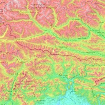
Name: Karnischer Hauptkamm topographic map, elevation, terrain.
Location: Karnischer Hauptkamm, Carinthia, Austria (46.50151 12.27875 46.74790 13.69222)
Average elevation: 1,437 m
Minimum elevation: 116 m
Maximum elevation: 3,672 m
Make a donation
Gear up for your next adventure:
As an Amazon Associate, this site earns from qualifying purchases at no extra cost to you.
Other topographic maps
Click on a map to view its topography, its elevation and its terrain.
Seebach
Austria > Carinthia > Bezirk Spittal an der Drau > Seeboden am Millstätter See
Average elevation: 654 m
Haber
Austria > Carinthia > Bezirk Klagenfurt-Land > Ebenthal in Kärnten > Obitschach
Average elevation: 580 m
Gaudritz
Austria > Carinthia > Bezirk St. Veit an der Glan > Micheldorf > Ostrog
Average elevation: 775 m
Make a donation
Gear up for your next adventure:
As an Amazon Associate, this site earns from qualifying purchases at no extra cost to you.
Turracher Höhe
Austria > Carinthia > Reichenau
The highest point of the approx. two km long pass summit has an altitude of 1,795 m above sea level south of the Turracher Lake. The lake has a water level of 1,763 m above sea (Adria) level and is connected to the village. The Turracher Höhe, as a "classic" pass summit, is also part of a drainage divide…
Average elevation: 1,852 m
Innerkrems
Austria > Carinthia > Bezirk Spittal an der Drau > Krems in Kärnten
Average elevation: 1,811 m
Burg Hochosterwitz
Austria > Carinthia > Bezirk Sankt Veit an der Glan > Launsdorf > Hochosterwitz
Average elevation: 568 m
Make a donation
Gear up for your next adventure:
As an Amazon Associate, this site earns from qualifying purchases at no extra cost to you.
Kleindombra
Austria > Carinthia > Bezirk Spittal an der Drau > Millstatt am See > Obermillstatt > Kleindombra
Average elevation: 814 m
Schmelzhütten
Austria > Carinthia > Bezirk Spittal an der Drau > Flattachberg > Schmelzhütten
Average elevation: 1,118 m
Make a donation
Gear up for your next adventure:
As an Amazon Associate, this site earns from qualifying purchases at no extra cost to you.