
Thank you for supporting this site ❤️
Make a donation
Make a donation
Gear up for your next adventure:
As an Amazon Associate, this site earns from qualifying purchases at no extra cost to you.
Blue Nile topographic map
Click on the map to display elevation.
Thank you for supporting this site ❤️
Make a donation
Make a donation
Gear up for your next adventure:
As an Amazon Associate, this site earns from qualifying purchases at no extra cost to you.
About this map
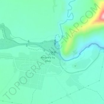
Name: Blue Nile topographic map, elevation, terrain.
Location: Blue Nile, Tis Abay, West Gojjam, Amhara Region, Ethiopia (11.48794 37.58689 11.48795 37.58695)
Average elevation: 1,648 m
Minimum elevation: 1,590 m
Maximum elevation: 1,836 m
Thank you for supporting this site ❤️
Make a donation
Make a donation
Gear up for your next adventure:
As an Amazon Associate, this site earns from qualifying purchases at no extra cost to you.