
Soneja topographic map
Click on the map to display elevation.
About this map
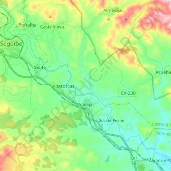
Name: Soneja topographic map, elevation, terrain.
Average elevation: 368 m
Minimum elevation: 171 m
Maximum elevation: 850 m
Other topographic maps
Click on a map to view its topography, its elevation and its terrain.
la Garrotxa
Spain > Valencian Community > Castelló / Castellón > Cervera del Maestre
Average elevation: 273 m
Vila-real
Spain > Valencian Community > Castelló / Castellón > Vila-real > Vila-real
Average elevation: 42 m