Geolocate

Valinhos topographic map

Click on the map to display elevation.

Valinhos

Valinhos (Portuguese pronunciation: ) is a municipality (município) in the state of São Paulo, Brazil. It is the birthplace of Adoniran Barbosa. Valinhos is famous for its purple fig, the theme of its annual Fig Fest. It is part of the Metropolitan Region of Campinas. The population is 131,210 (as of 2020) in an area of 148.54 square kilometres (57.35 square miles). Its elevation is 660 m (2,165.35 ft). Its name means 'little valleys' in Portuguese.

About this map

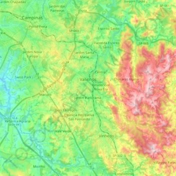
Name: Valinhos topographic map, elevation, terrain.

Location: Valinhos, Região Imediata de Campinas, Região Metropolitana de Campinas, Região Geográfica Intermediária de Campinas, São Paulo, Southeast Region, Brazil (-23.05646 -47.07529 -22.90309 -46.87453)

Average elevation: 729 m

Minimum elevation: 580 m

Maximum elevation: 979 m

Gear up for your next adventure:

🧢Hiking Hat - Sun-protective and breathable hats for long treks
🪑Insulated Seat Pad - Protect your seat from cold rocks and wet logs
🥾Light Trekking Boots - Supportive boots for multi-day treks
Lightweight Camping Tent - Portable shelter optimized for Canadian backcountry camping
🔦LED Headtorch - Bright and durable light for night activities

As an Amazon Associate, this site earns from qualifying purchases at no extra cost to you.