
Manuel de Echeandia topographic map
Interactive map
Click on the map to display elevation.
About this map
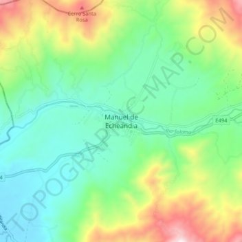
Name: Manuel de Echeandia topographic map, elevation, terrain.
Location: Manuel de Echeandia, Echeandía, Bolívar, 020401, Ecuador (-1.47199 -79.31974 -1.39199 -79.23974)
Average elevation: 486 m
Minimum elevation: 186 m
Maximum elevation: 1,155 m
Other topographic maps
Click on a map to view its topography, its elevation and its terrain.
Las Casitas
Ecuador > Bolívar > Echeandía > Manuel de Echeandia
Las Casitas, Manuel de Echeandia, Echeandía, Bolívar, Ecuador
Average elevation: 443 m