
Make a donation
Gear up for your next adventure:
As an Amazon Associate, this site earns from qualifying purchases at no extra cost to you.
Quebrada Mucuñuque topographic map
Click on the map to display elevation.
Make a donation
Gear up for your next adventure:
As an Amazon Associate, this site earns from qualifying purchases at no extra cost to you.
About this map
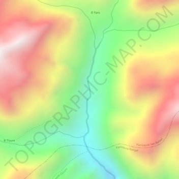
Name: Quebrada Mucuñuque topographic map, elevation, terrain.
Average elevation: 3,400 m
Minimum elevation: 2,959 m
Maximum elevation: 3,810 m
Make a donation
Gear up for your next adventure:
As an Amazon Associate, this site earns from qualifying purchases at no extra cost to you.
Other topographic maps
Click on a map to view its topography, its elevation and its terrain.
Mucuchíes
Venezuela > Estado Mérida > Municipio Rangel
Mucuchíes es una ciudad venezolana, ubicada en el municipio Rangel del estado Mérida. Situado a 8°45' de latitud Norte y a 70°55' de longitud oeste, se encuentra a una altitud de 2.983 m s. n. m., siendo uno de los pueblos a mayor altura de Venezuela, de hecho es catalogado como el pueblo a mayor altitud…
Average elevation: 3,403 m
Make a donation
Gear up for your next adventure:
As an Amazon Associate, this site earns from qualifying purchases at no extra cost to you.
Mucuchíes
Venezuela > Estado Mérida > Municipio Rangel
Mucuchíes es una ciudad venezolana, ubicada en el municipio Rangel del estado Mérida. Situado a 8°45' de latitud Norte y a 70°55' de longitud oeste, se encuentra a una altitud de 2.983 m s. n. m., siendo uno de los pueblos a mayor altura de Venezuela, de hecho es catalogado como el pueblo a mayor altitud…
Average elevation: 3,403 m
Make a donation
Gear up for your next adventure:
As an Amazon Associate, this site earns from qualifying purchases at no extra cost to you.
Mucuchíes
Venezuela > Estado Mérida > Municipio Rangel
Mucuchíes es una ciudad venezolana, ubicada en el Municipio Rangel del Estado Mérida. Situado a 8°45' de latitud Norte y a 70°55' de longitud oeste, se encuentra a una altitud de 2.983 m s. n. m., siendo uno de los pueblos a mayor altura de Venezuela, de hecho es catalogado como el pueblo a mayor altitud…
Average elevation: 3,403 m