
Chardonne topographic map
Click on the map to display elevation.
About this map
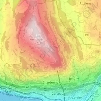
Name: Chardonne topographic map, elevation, terrain.
Average elevation: 737 m
Minimum elevation: 368 m
Maximum elevation: 1,087 m
Other topographic maps
Click on a map to view its topography, its elevation and its terrain.
Les Avants
Switzerland > Vaud > District de la Riviera-Pays-d’Enhaut > Montreux
Average elevation: 1,111 m
Le Crêt
Switzerland > Vaud > District de la Riviera-Pays-d’Enhaut > Rougemont
Average elevation: 1,229 m
Pallens
Switzerland > Vaud > District de la Riviera-Pays-d’Enhaut > Montreux > Chernex
Average elevation: 596 m
Le Mont-Pèlerin
Switzerland > Vaud > District de la Riviera-Pays-d’Enhaut > Chardonne > Le Mont-Pèlerin
Average elevation: 666 m