
Make a donation
Gear up for your next adventure:
As an Amazon Associate, this site earns from qualifying purchases at no extra cost to you.
Schönenberg-Kübelberg topographic map
Click on the map to display elevation.
Make a donation
Gear up for your next adventure:
As an Amazon Associate, this site earns from qualifying purchases at no extra cost to you.
Schönenberg-Kübelberg
The municipality of Schönenberg-Kübelberg lies in the Western Palatinate near the boundary with the Saarland some 15 km south of Kusel, and 10 km northeast of Homburg. The two Ortsteile lie at the edge of the Landstuhler Bruch (a hollow). Kübelberg on the long mountain ridge south of the Klingbach runs seamlessly into Schönenberg to the east, while Schönenberg also melds without a break with the outlying centre of Sand. Within the municipality, the land rises from 241 m above sea level at the edge of the brook up to 264 m near the church in Kübelberg. Outside the built-up area, the highest elevations in the municipal area reach some 300 m above sea level in the Steinwald and Peterswald (forests).
Make a donation
Gear up for your next adventure:
As an Amazon Associate, this site earns from qualifying purchases at no extra cost to you.
About this map
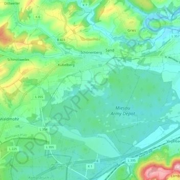
Name: Schönenberg-Kübelberg topographic map, elevation, terrain.
Average elevation: 268 m
Minimum elevation: 221 m
Maximum elevation: 396 m
Make a donation
Gear up for your next adventure:
As an Amazon Associate, this site earns from qualifying purchases at no extra cost to you.
Other topographic maps
Click on a map to view its topography, its elevation and its terrain.
Schönenberg
Germany > Rhineland-Palatinate > Landkreis Kusel > Schönenberg-Kübelberg
Average elevation: 266 m