Geolocate

Khevi topographic map

Click on the map to display elevation.

About this map

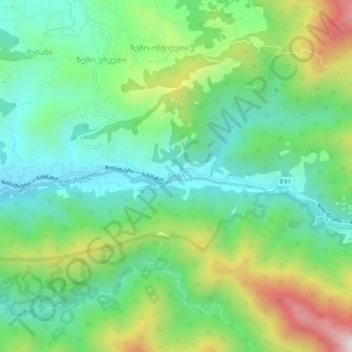
Name: Khevi topographic map, elevation, terrain.

Location: Khevi, Chokhatauri Municipality, Guria, Georgia (41.94003 42.26812 41.98003 42.30812)

Average elevation: 454 m

Minimum elevation: 207 m

Maximum elevation: 976 m

Gear up for your next adventure:

🧭GPS Tracker - Track your location in remote areas safely
🥾Waterproof Trail Shoes - Shoes designed to handle wet terrain
❄️Traction Ice Cleats - Slip-on spikes for icy trails and winter hiking
🚲Handlebar Phone Mount - View topographic-map.com live while cycling
🧼Biodegradable Camp Soap - Environmentally friendly cleaning for gear and body

As an Amazon Associate, this site earns from qualifying purchases at no extra cost to you.