
Thank you for supporting this site ❤️
Make a donation
Make a donation
Gear up for your next adventure:
As an Amazon Associate, this site earns from qualifying purchases at no extra cost to you.
Pazhaverkadu topographic map
Click on the map to display elevation.
Thank you for supporting this site ❤️
Make a donation
Make a donation
Gear up for your next adventure:
As an Amazon Associate, this site earns from qualifying purchases at no extra cost to you.
About this map
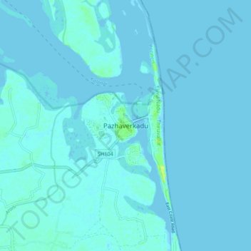
Name: Pazhaverkadu topographic map, elevation, terrain.
Location: Pazhaverkadu, Ponneri, Thiruvallur, Tamil Nadu, India (13.37766 80.27667 13.45766 80.35667)
Average elevation: 1 m
Minimum elevation: -2 m
Maximum elevation: 14 m
Thank you for supporting this site ❤️
Make a donation
Make a donation
Gear up for your next adventure:
As an Amazon Associate, this site earns from qualifying purchases at no extra cost to you.
Other topographic maps
Click on a map to view its topography, its elevation and its terrain.
Temple Tank (Sri Varadharaja perumal Temple)
India > Tamil Nadu > Ponneri > Minjur
Average elevation: 7 m