
Make a donation
Gear up for your next adventure:
As an Amazon Associate, this site earns from qualifying purchases at no extra cost to you.
Waasten topographic map
Click on the map to display elevation.
Make a donation
Gear up for your next adventure:
As an Amazon Associate, this site earns from qualifying purchases at no extra cost to you.
Waasten
Waasten ligt aan de Leie die hier sinds 1713 de grens met Frankrijk vormt. De gekanaliseerde Leie ligt hier iets ten zuiden van de grens, op Frans grondgebied. Daar ligt ook Warneton, een kleine gemeente in Frankrijk waarvan het grondgebied in 1713 van Waasten werd afgesplitst. Waasten ligt op een hoogte van ongeveer 18 meter.
Make a donation
Gear up for your next adventure:
As an Amazon Associate, this site earns from qualifying purchases at no extra cost to you.
About this map
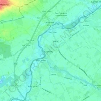
Name: Waasten topographic map, elevation, terrain.
Average elevation: 20 m
Minimum elevation: 9 m
Maximum elevation: 65 m
Make a donation
Gear up for your next adventure:
As an Amazon Associate, this site earns from qualifying purchases at no extra cost to you.
Other topographic maps
Click on a map to view its topography, its elevation and its terrain.
Le Gheer - Gheer
België > Henegouwen > Doornik-Moeskroen > Komen-Waasten > Waasten
Average elevation: 21 m