Geolocate

Valga topographic map

Click on the map to display elevation.

About this map

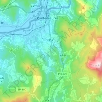
Name: Valga topographic map, elevation, terrain.

Location: Valga, Caldas, Pontevedra, Galicia, España (42.65885 -8.72667 42.71969 -8.59363)

Average elevation: 161 m

Minimum elevation: -2 m

Maximum elevation: 711 m

Other topographic maps

Click on a map to view its topography, its elevation and its terrain.

Vilar de Mato

España > Galicia > Caldas > Cuntis

Average elevation: 411 m

Fervenza de Segade

España > Galicia > Caldas > Caldas de Reis

Average elevation: 137 m

Vilameán

España > Galicia > Caldas > Cuntis

Average elevation: 225 m

Marán

España > Galicia > Caldas > Caldas de Reis

Average elevation: 93 m

Mesego

España > Galicia > Caldas > Cuntis

Average elevation: 405 m

Arcos da Condesa

España > Galicia > Caldas > Caldas de Reis

Average elevation: 103 m

Os Barreiros

España > Galicia > Caldas > Caldas de Reis

Average elevation: 86 m

Gear up for your next adventure:

🔋Emergency Crank Radio - Weather alerts and power without needing batteries
🔥Emergency Fire Starter - Reliable ignition source for all weather conditions
📷Outdoor Action Camera - Capture high-elevation views and rugged adventures
🔋Solar Power Bank - Keep your GPS and devices charged during long outdoor trips
🎒Backpack Rain Cover - External shield to keep your entire pack dry

As an Amazon Associate, this site earns from qualifying purchases at no extra cost to you.